What is a watershed?
A watershed is an area of land that holds water that eventually drains into a large body of water, like a lake, river, or ocean. We all live in a watershed, although sometimes we refer to watersheds as basins. In Alberta, there are seven major river basins or watersheds: the Hay, Peace/Slave, Athabasca, Beaver, North Saskatchewan, South Saskatchewan, and the Milk. Our river basins are crucial resources that we rely on for drinking water, industry, and recreation. Everything we do on the landscape impacts our water bodies.
The boundaries of a watershed are determined by the topography of the landscape. Mountains or ridges (like the Rockies) are the natural dividers of watersheds. The Continental Divide is an example of a large ridge that divides river systems that flow into the west (into the Pacific Ocean) from river systems that flow into the east (into the Atlantic or the Arctic Oceans).
Water is everywhere. It’s in lakes, sloughs, and puddles. It’s in rivers, creeks, streams, and underground aquifers. It comes from rain, snow, hail, and melting glaciers. All water flows downhill, and if that water eventually ends up in the Athabasca River, then it’s in our watershed.
The Athabasca Watershed
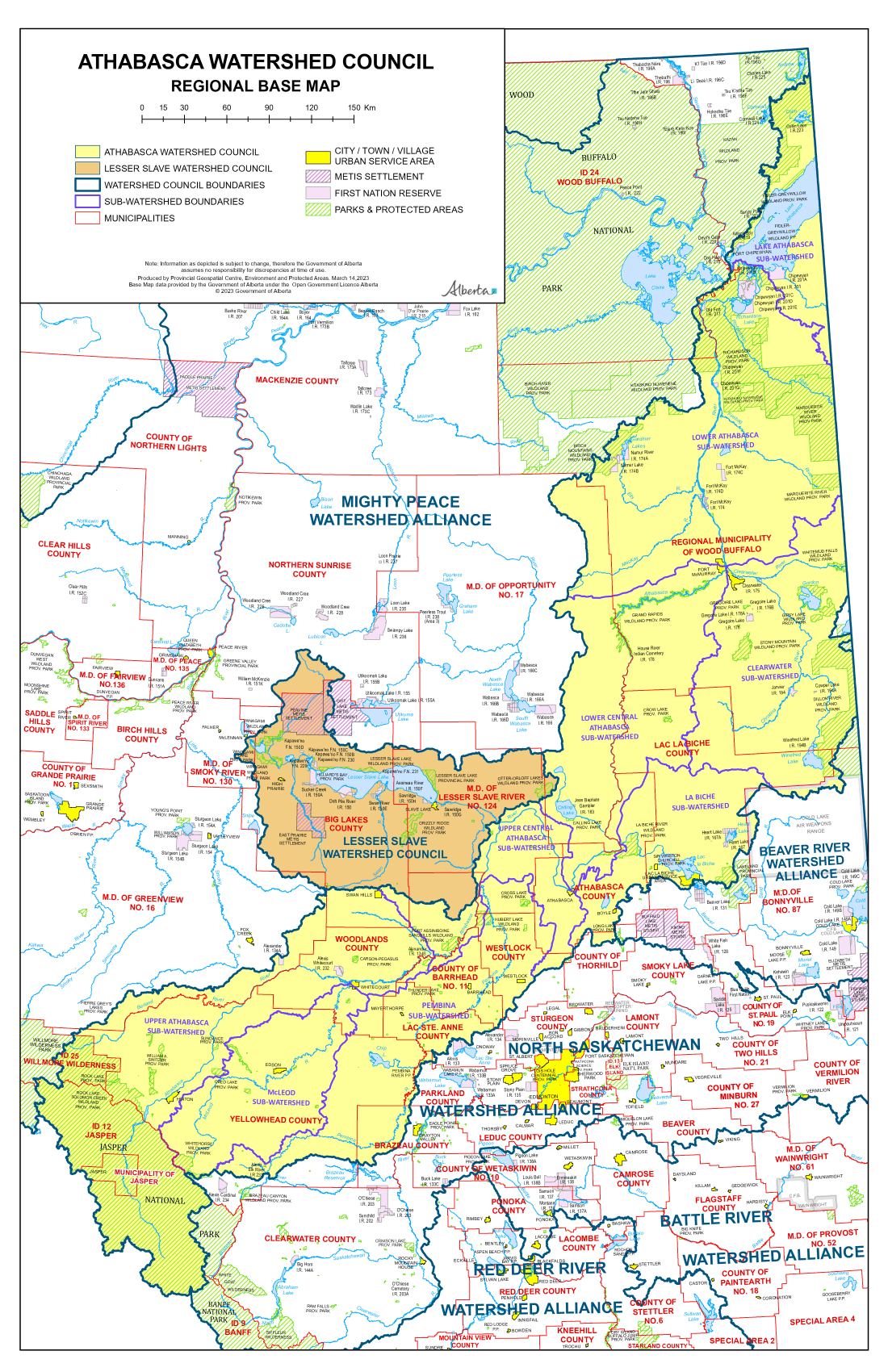
The Athabasca River is approximately 1,231 km long, flowing from the Columbia Icefield in Jasper National Park, through Foothills, Boreal Forest and Canadian Shield, all the way to Lake Athabasca – an elevation change from 3747 to 208 metres. From there the waters flow northwest through the Peace / Slave / Mackenzie River system to the Arctic Ocean. The mean annual discharge of the river gets calculated at 3 locations, and is recorded in cubic decametres (1 dam³ = 1000 cubic metres). In Jasper it is 2,790,000 dam³; at the Town of Athabasca, it is 13,600,000 dam³; at Fort McMurray, it is 20,860,000 dam³. The Athabasca River watershed is 159,000 square km in size, covering roughly 24% of Alberta’s landmass. This region is diverse, including all or parts of 13 Municipal Districts, 3 Specialized Municipalities, 10 Towns, 9 Summer Villages, 1 village and 4 Improvement Districts. It spans portions of Treaty 6, Treaty 8 and Treaty 10 territories and is the home of many Indigenous people. It includes several major tributaries such as the Pembina, McLeod, Lesser Slave, Lac La Biche and Clearwater rivers. It also contains several working landscapes that support agriculture, forestry, oil and gas, recreation and more.
To manage the water that we all depend on, we must manage the land that we share. To do that, let’s come together to understand the issues, challenges, and opportunities affecting our watershed. The Athabasca Watershed Council works to bring stakeholders, citizens, and Indigenous peoples together to effectively manage the Athabasca River Watershed.
Support your watershed.
Help us provide programming and educational opportunities.